Diving Deep for Volcanic Deposits: What the Hunga Volcanic Eruption Teaches Us About the Deep Sea
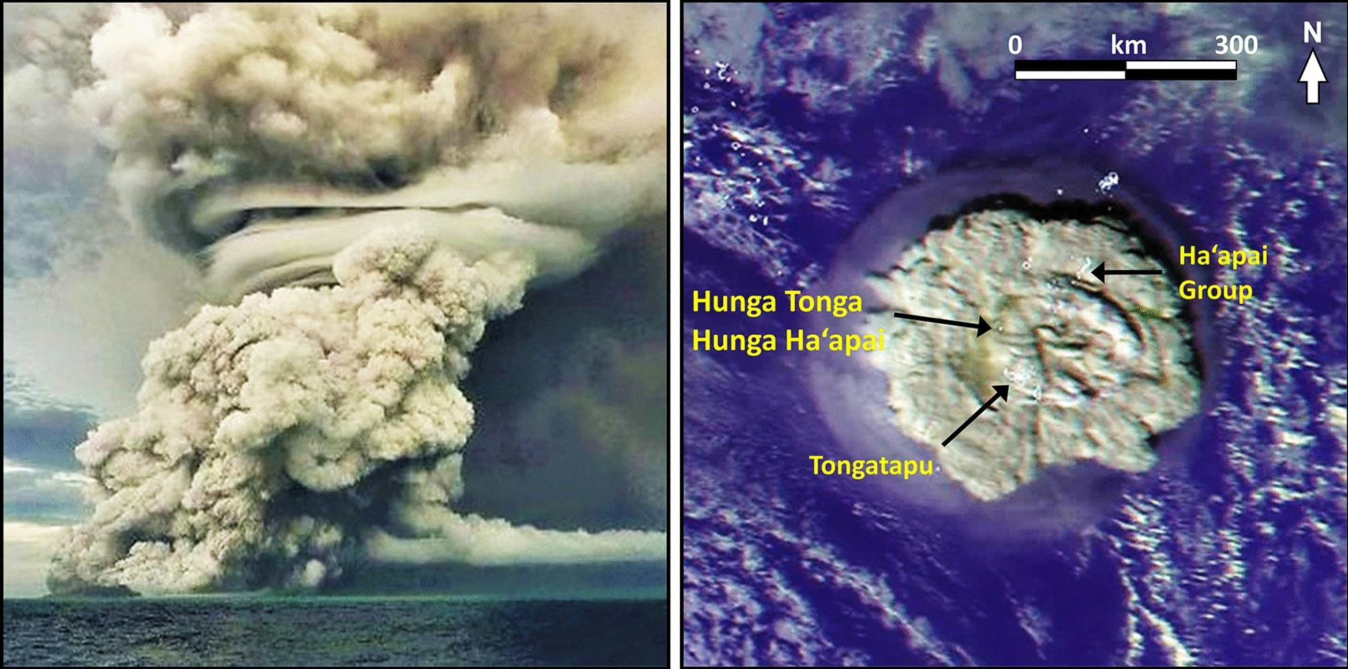
Featured Image Caption: Eruption of the Hunga Tonga-Hunga Ha’apai volcano on January 15, 2022. Image source: Figure 3 from Terry, J. P., Goff, J., Winspear, N., Bongolan, V. P., & Fisher, S. (2022). Tonga volcanic eruption and tsunami, January 2022: globally the most significant opportunity to observe an explosive and tsunamigenic submarine eruption since AD 1883 Krakatau. Geoscience Letters, 9(1), 1–11.
Primary Source Article:
Chaknova, M., Giachetti, T., Paredes-Mariño, J., Soule, A., Van Eaton, A., Beinart, R., Crundwell, M., Cronin, S., Jutzeler, M., Fauria, K., Clare, M., Yeo, I., Arellano, S., Kelly, L., Watson, S., Carey, R., Kula, T., & Young, C. (2025). How did westward volcaniclastic deposits accumulate in the deep sea following the January 2022 eruption of Hunga Volcano? Geochemistry, Geophysics, Geosystems, 26(1). https://doi.org/10.1029/2024GC011629
Secondary Source Article (s):
Terry, J. P., Goff, J., Winspear, N., Bongolan, V. P., & Fisher, S. (2022). Tonga volcanic eruption and tsunami, January 2022: globally the most significant opportunity to observe an explosive and tsunamigenic submarine eruption since AD 1883 Krakatau. Geoscience Letters, 9(1), 1–11. https://doi.org/10.1186/s40562-022-00232-z
Fiantis, D., Ginting, F. I., Seprianto, Halfero, F., Saputra, A. P., Nelson, M., Van Ranst, E., & Minasny, B. (2021). Geochemical and mineralogical composition of the 2018 volcanic deposits of Mt. Anak Krakatau. Geoderma Regional, 25, e00393. https://doi.org/10.1016/j.geodrs.2021.e00393
In January 2022, the Hunga Volcano erupted in the South Pacific Ocean in the Kingdom of Tonga. The volcanic eruption triggered a tsunami, sent a shockwave around the world, and destroyed telecommunication cables 85 km from the source. Regrettably, three deaths were reported: one in Tonga and two in Peru. The event was a sobering demonstration of how little we know about undersea volcanoes. Four months after the event, Chaknova and colleagues visited 11 sites across 6 hydrothermal vents to study volcanic deposits from the Hunga volcano eruption to better understand how shallow submarine volcanoes change the ocean’s surface. Their study provided a rare opportunity to observe how the ocean’s surface changed after the Hunga eruption. It also revealed that undersea volcanoes affect carbon and nutrient transport to deep-sea basins more significantly than previously believed.

Hunga Tonga-Hunga Ha’apai: The Ever Changing Island

The Hunga Tonga Hunga Ha’apai (HTHH) island is a volcanic island belonging to the caldera rim of a submerged undersea volcano. A volcano caldera is a bowl-shaped hole formed when a volcano collapses inward after erupting and draining. Sometimes, magma can be re-injected into the area and cause landforms to lift and rise above sea level. In the case of the Hunga Tonga-Hunga Ha’apai, two pre-existing islands were joined by undersea eruptions into a single land mass before separating again after the eruption. The island was home to shrubs, grasses, insects, and birds. The ecosystems on land and underwater will recover but the timeline is uncertain. The news and satellite observations of the eruption focused on changes of the HTHH island. Careful observation was important for safety, health hazards, and scientific investigation. However, there were equally important changes that needed to be studied beneath the sea
Geologic Context: The Hunga Tonga-Hunga Ha’apai, the Lau Basin, and the Tafua Arc
The undersea volcano that was studied is located in the Lau Basin. Ocean basins are depressions in the Earth formed by continental shelves. Tectonic activity is what changes the shape of ocean basins through melting, shifting, and sliding of enormous chunks of Earth’s outer, rocky crust. In the case of the Lau Basin, this basin is divided into three major areas: the Western Basin, the Eastern Basin, and the Tofua Arc. The scientists collected samples of volcanic deposits from between the Eastern Basin and the Tofua Arc undersea.
The Lau Bain has the fastest spreading center on Earth, with high hydrothermal vent and volcanic activity. Undersea volcanic activity happens frequently, but is poorly understood because things can change before scientists get out to study them. In the case of the Hunga volcanic eruption, scientists had a rare opportunity to study a recent eruption before the clues would disappear into the morphing basin.
The Give and Take of Volcanic Deposits
Volcanic deposits are important because they make fertile soils and contain materials valuable for construction and other purposes. These deposits also tell a story of which volcano it belongs to and how land masses are formed. Volcanic deposits contain a mixture of igneous rock, volcanic glass, sand, ash, and minerals such as: phosphorous, potassium, silicon, aluminum, iron, copper, gold, silver, lead, and zinc. Conversely, volcanic deposits can also contaminate water and soil sources, negatively impacting living organisms. They can contribute to the destruction and creation of ecosystems.
Scientists Get to Work 4 Months After Volcanic Eruption

Imagine an intact jigsaw puzzle torn up and then scattered across multiple locations. You are trying to find the pieces of the puzzle. You know where the intact puzzle was torn apart and have an idea of where it fell, but your task is made challenging because there are older jigsaw puzzle fragments from unrelated puzzles you are not interested in scattered in the locations you think your jigsaw pieces fell.
For the scientists, they were playing the role of geologic detectives post-eruption finding scattered pieces. They wanted to better understand the path the volcanic eruption took and understand what made up the deposits. Gathering information about the composition of volcanic deposits and how far they have traveled can offer valuable insights into several key aspects: the maximum distance a volcano can eject material, the impact on surrounding ecosystems, and whether individual eruptions can be distinguished from previous ones.
To accomplish this task, a remotely operated vehicle named Jason collected samples from five active hydrothermal vent fields and one inactive field along the Eastern Lau arc basin. These vent fields were approximately 200 km west of the Hunga volcano and 3 km below the ocean’s surface. To retrieve sediment samples from the seabed, Jason used a core barrel to retrieve push cores and scoop bags to pick up volcanic deposits. Once samples were collected, they looked at the elements and compounds in the material, studied the grain size and textures, and looked at microfossils embedded in the sediments.

Rock Textures and Bioclasts Provide the Clues

The scientists wanted to determine that the deposits they collected from the Lau basin belonged to the Hunga volcano. They accomplished this by comparing the major element concentrations and grain size of their sample with ash samples collected on land a day after the Hunga eruption. In addition they compared the microfossils of bioclasts, once living organisms found in sedimentary rock to a sample collected from the Lau Basin on a former 1980 voyage. Finally, they studied the glass composition of the samples they collected with the recent ash of the volcano. Collectively, these tests confirmed that the samples they collected belonged to the volcano.
Using their fragmented clues, they were able to explain two main methods on how the volcanic deposits moved 80-100 km. Part of the volcanic contents shot up from the air and settled directly underneath the eruption in the seawater and/or other contents from the volcano hugged the seabed floor and followed the SW and NW down to the Lau Basin.
As the volcanic current swept across the floor, it was able to carry with it fossilized single celled, microscopic organisms from its place of origin and recently deceased organisms, modern day, phaodarians. Scientists compared these organisms to a map of bioclasts in the Lau Basin before the eruption. Doing so helped them understand how the NW and SW currents operated differently traveling with different content of microfossils. Some of the currents carried ash far away, whereas other currents carried recently deceased organisms at a slower pace. Overall, scientists were surprised by the distance the volcanic content travelled and realized that underwater flows of volcanic material play a greater role in carbon transport into deep sea basins than originally thought.
When the Dust Settles: Why is This Important?
Chaknova and colleagues had the rare opportunity to study volcanic deposits at long distances before it mixed in with the Lau Basin. The data from this study helps us understand volcanic impacts on ecosystems, the evolution of the sea floor, and similar processes on Mars. Algal blooms were detected where the ash had settled. These blooms affected the fishing and coral reefs for the country of Tonga. Although studying volcanoes is a cool scientific endeavor, it is also one that could save lives. The ash that fell nearby affected crops and affected the respiratory health of people. Unfortunately, nearby communities were only given a 15 minute warning before the Tonga Volcano exploded and three people died. Hopefully, this data along with future studies helps us to predict upcoming volcanic eruptions and tsunamis.
Want to learn more about volcanoes? Check out these cool links/references for more learning!
https://www.whoi.edu/know-your-ocean/ocean-topics/how-the-ocean-works/seafloor-below/volcanoes/
https://www.nps.gov/subjects/volcanoes/lava-flows-and-other-volcanic-deposits.htm
https://doi.org/10.1029/2022GL100248
https://www.agu.org/channel/tonga-volcano-eruption-2022
https://phys.org/news/2022-08-tonga-volcano-eruption-metersnine-taller.html
https://volcano.si.edu/volcano.cfm?vn=243040
Reviewed by: